
Christopher Columbus was a deluded man – thank God! He convinced himself that he could island-hop his way to Asia. And many fellow Italians provided the maps that fed his delusion.
It started with his own experience as a young sailor venturing out into the Atlantic Ocean. In 1477, he sailed to Iceland and wintered over. Icelanders say that he learned of Greenland and possibly the saga of Leif Erikson’s voyage further west. He came to appreciate how many islands dotted the Earth. Clearly, the Vikings explored their northern climes by island-hopping.
Europeans already knew of island chains off their coast like the Azores, some 1,000 miles far into the Atlantic from Portugal. They knew of the Madeira Archipelago 500 miles off the coast of North Africa; of the Cape Verde Islands 500 miles from Senegal, Africa; and the Canaries 150 miles from Morocco.
Who discovered the Azores? Historians don’t know for sure but one guess is that they were sighted by a Portuguese expedition on its way back from the Canary Islands in 1341. Need I tell you that the navigators on that voyage were Italian? They were Florentine Angiolino del Tegghia de Corbizzi and the Genoese Nicoloso da Recco.
The Cape Verde Islands are made up of two chains. One chain was discovered in 1456 by a team that included navigator Alvise Ca’ da Mosto, an Italian working for Portugal. The other chain was discovered in 1462 by Antonio da Noli, another paesano working for Portugal.
Around 1479, Columbus ventured to the Madeira Archipelago where he met and married his first wife Filipa Perestrello. If that name sounds Italian it’s because she was the daughter of Bartolomeo Perestrello who co-discovered Madeira for Portugal and became its first governor.
Islands had to be an obsession for Columbus. The spice islands of East Asia were his goal as was the island of Cipangu (Japan) and continental Cathay (China). He just needed the right charts for each coast of the Atlantic – of islands that would shorten any perilous voyage.
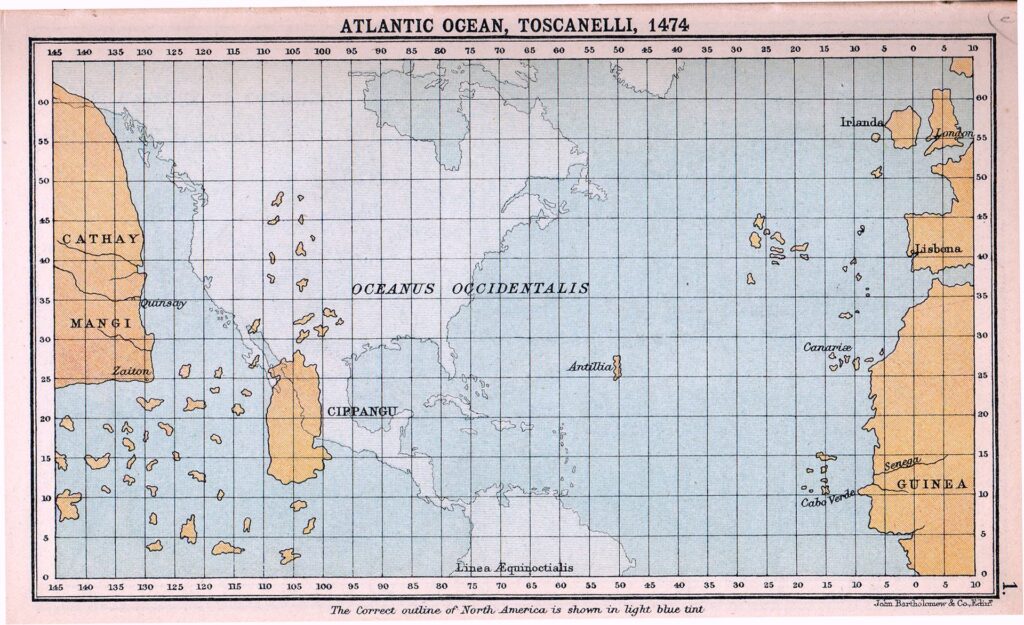
Medieval Italy was the epicenter of chart-making. The Azores first appeared on the Medici Atlas in 1351; and later on the Pizzigani brothers chart of 1367. Angelino Dalorto (or Dulceti) was a Genoese chartmaker who lived off the coast of Spain (Majorca) in the 1320s or 1330s where he plotted islands and trade routes. Columbus studied all of them and had a special admiration for Paolo dal Pozzo Toscanelli who inspired him to sail west to the Orient.
But, a man obsessed is bound to miscalculate. Historians agree that Columbus and many of the chart makers underestimated the Earth’s circumference by almost 25%. Even the ancient Greeks and later the Arabs had the right figures. Yet, Columbus chose to believe the Indies were only 2,500 miles from Europe. In reality, they were more than 11,000 miles away – a deathtrap for any adventurer. His Italian mapmakers had erred in plotting Asia 5,000 miles wider than it was, making the trip across the Atlantic only a risky excursion. And don’t forget the real and imagined islands they added willy-nilly.
With islands in mind, why didn’t Columbus start his voyage from the Azores – 1,000 miles closer to Asia. First, they were owned by Portugal not Spain. Second, the prevailing winds blow the wrong way. Third, they were too far north to match the latitude of the Spice Islands. So, Columbus settled on sailing to the more southern Canary Islands from Spain, as his first leg.
The Canaries were Spanish and on the right latitude, with prevailing winds that would push him westward. And, they were 150 miles into the Atlantic. In 1492, the Atlantic was calm and the winds just right. His Italian mapmakers were the best in the world and his trust in the Almighty pushed any doubts from his mind. But we know he was a dead man sailing had there not been two new continents in his path – actually those islands of the Caribbean.
One last irony: If Columbus had sailed from the Azores, he would be only 2,500 miles from Manhattan Island, the distance he originally calculated for Asia. – JLM


I think that we need to remind ourselves that like Columbus, with all our faults, God has something he wants us to accomplish. While religious answers are not in vogue these days, I firmly believe that good he accomplished was the result of his faith.
We were blessed when he came to the new world. Since he was human, he did great things and things he should not have done.
Who can cast the first stone, who is perfect?
Even the things he did wrong, he was forced to do. Remember he was arrested and sent back to Spain in chains for hanging Spaniards who were mistreating the natives. He was exonerated by the monarchs. As for sending slaves back – they were natives who had warred against the Spaniards and murdered 40 sick men in a hospital. The natives were POWs and the universal practice in both the Old and New Worlds was for POWs to be enslaved. The new colonists that he brought in 1493 considered Columbus to be too lenient with the natives and introduced a system to make the natives serfs tied to colonist land. Columbus could not overrule them.
And no anti-Columbus people ever recall that the natives massacred 39 of Columbus’s crew in 1492 when he left them on Hispaniola after the Santa Maria sank. When Columbus returned in 1493 he took no revenge. But he realized that not all Tainos were “gentle” or trustworthy.
Modern Italy too can be considered the epicenter of marine chart-making. The world’s first marine electronic chart plotter was in fact invented in Italy in 1984 by Navionics, which is still one of the most popular manufacturers of electronic navigational charts worldwide.
Columbus the Discoverer, connector of Two Worlds and a Man of his times! Happy Columbus Day 2022!
Another great article, Giovanni M!
Applause for all of the above comments. Mediacrats who love to push the “dumb dago” narrative would drop dead from shame (one hopes) if they took the time to read such things. The idea of an intelligent Italian strikes them as completely bogus.
If they wanted to find some, they could. But they don’t. It’s easier to spread bias.
Case in point: Jersey Shore. The producers went out-of-their way to find low-lives who fit their perceptions of dumb dagoes. Yet contrast the empty-headed thrill-seekers on Jersey Shore with, say, San Fran 49ers quarterback Jimmy Garoppolo or comedian Sebastian Maniscalco, both college-educated Italian American men.
And yet, it’s the losers on Jersey Shore whom the media considers “Italian” (!!).